
Greenpeace and Friends of the Earth fined for breaking campaigning rules
By Paul Homewood h/t Joe Public Greenpeace Ltd and Friends of the Earth Limited have been fined by the Electoral Commission for failing to comply with campaigning rules at the 2015 UK Parliamentary General Election. At the general election, non-party campaigners were required to register with the Electoral Commission if they spent more than either £20,000 campaigning in England or £10,000 campaigning in Wales.
Source: Greenpeace and Friends of the Earth fined for breaking campaigning rules…
Trump Meets With Italy’s Prime Minister After Refusing To Sign His Global Warming Pledge
‘The President should not listen to Washington’s Swamp’
Source: Trump Meets With Italy’s Prime Minister After Refusing To Sign His Global Warming Pledge…
Unusual Cold Wave & Heavy Snows Hit Europe
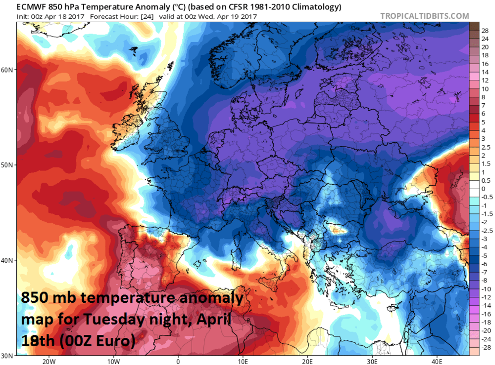
Lower atmosphere (850 mb, ~5000 feet) temperature anomaly forecast map for tonight across Europe by the 00Z Euro model; map courtesy tropicaltidbits.com
Overview
A cold wave has hit Europe and it looks like much of the continent will stay well below normal right through the rest of the month of April. In addition to the unusual cold, heavy snow accumulations are likely over the next ten days in many higher elevation locations (e.g., Alps) and accumulating snow is probable as far south as southern Italy and Greece.
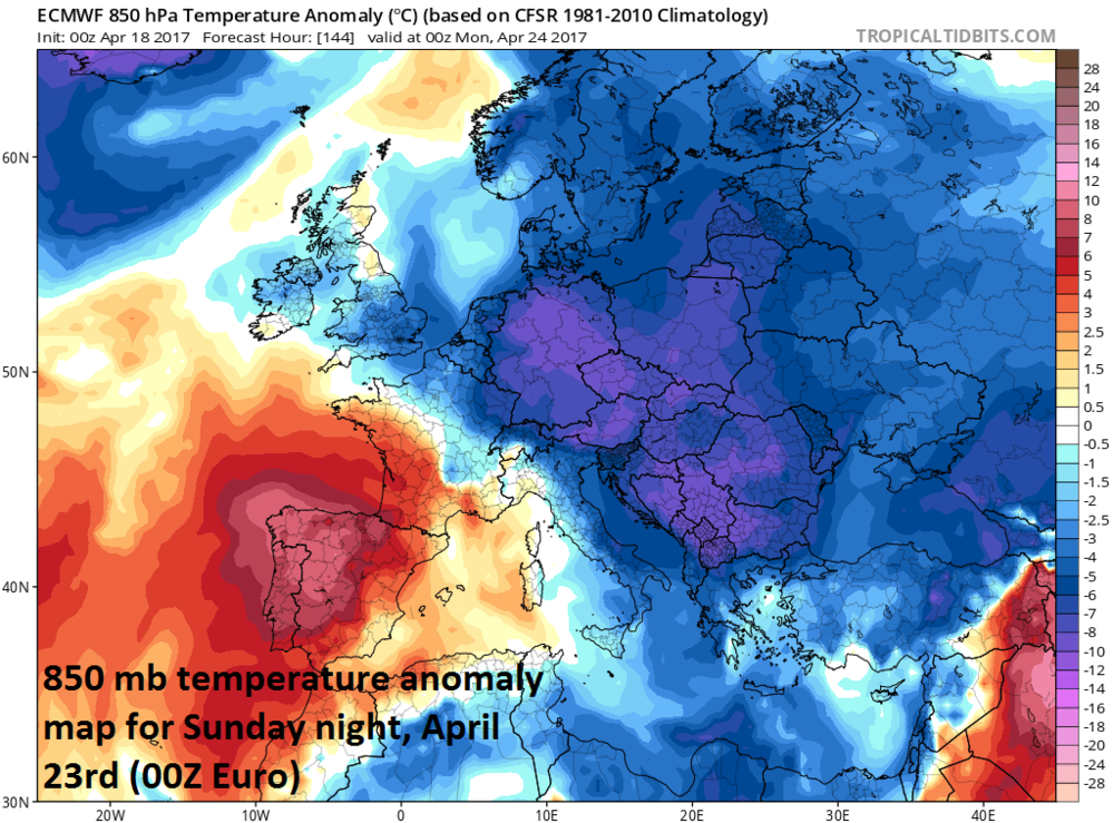
Lower atmosphere (850 mb, ~5000 feet) temperature anomaly forecast map for Sunday night, April 23rd across Europe by the 00Z Euro model; map courtesy tropicaltidbits.com
Details
Much of Europe is currently experiencing temperatures that are some 10-15 degrees (C) below normal for this time of year and it looks like there will be two or three additional cold air outbreaks during the next ten days or so. The temperature anomaly maps from last night’s 00Z European model for the lower atmosphere (850 millibars) suggest reinforcing cold air outbreaks will prevent any sustained return to normalcy for Europe in the near term. Well below normal temperatures are predicted throughout Europe not only for tonight, but also late in the upcoming weekend with the next cold air outbreak, and then again late next week with yet another cold blast.
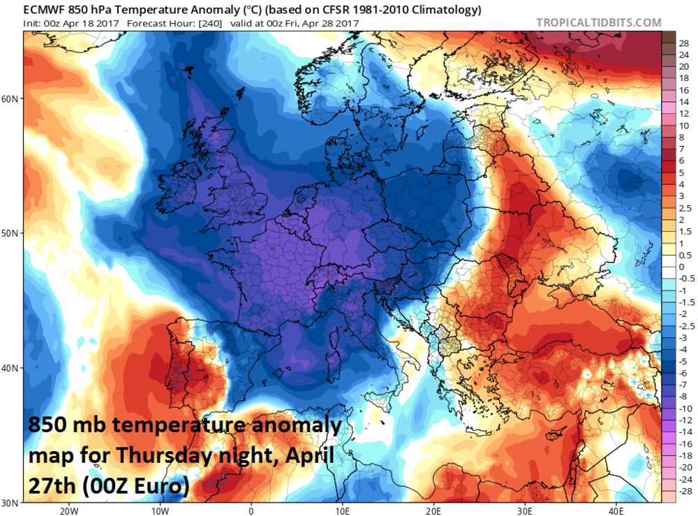
Lower atmosphere (~5000 feet) temperature anomaly forecast map for Thursday night, April 27th across Europe by the 00Z Euro model; map courtesy tropicaltidbits.com
In addition to the cold, snow will accumulate to substantial levels in parts of the Alps where skiing will be quite good going well into the month of May. The 00Z GFS ten-day total snowfall map (below) for Europe has more than two feet of snow in some of the higher elevation locations of central Europe and accumulating snow as far south as southern Italy and Greece.

00Z GFS total snowfall map for the next ten-days across Europe; map courtesy tropicaltidbits.com, NOAA/EMC
On occasion, the weather pattern in Europe can be a signal for upcoming weather conditions in the eastern US and while there are cold air outbreaks headed this way over the next couple of weeks, it does not look like they will be quite as widespread or sustained compared to what Europe is experiencing.
Meteorologist Paul Dorian
Vencore, Inc.
Cheers! Trump Refuses To Sign G7 Statement Endorsing UN Paris Climate Agreement
The U.S. refused to sign onto a statement with other G7 countries to commit to the implementation of the Paris climate agreement, which President Donald Trump promised to withdraw from on the campaign trail.
Secretary of Energy Rick Perry said the U.S. “is in the process of reviewing many of its policies and reserves its position on this issue, which will be communicated at a future date,” Italy’s industry and energy minister Carlo Calenda said in a statement.
Calenda said other G7 members “reaffirmed their commitment towards the implementation of the Paris Agreement to effectively limit the increase in global temperature well below 2°C above pre-industrial level.”
The Trump administration would not sign onto a statement mentioning Paris, since the president is still deciding whether or not to keep his campaign pledge. Perry also wanted the G7 to include support for coal and natural gas in its statement.
“Therefore, we believe it is wise for countries to use and pursue highly efficient energy resources,” Perry said in a statement after his meeting in Rome with energy ministers from Canada, France, Germany, Italy, Japan, the UK and the European Union.…
EU’s Roger Helmer’s Speech to Heartland Skeptics Summit in Washington
Good evening Ladies and Gentlemen, Friends and Colleagues, and greetings from the European parliament. You’ve just seen a speech I gave a couple of weeks back in the plenary session in Strasbourg. If you’re wondering why there were so few members in the chamber — that’s because it was about 10:30 at night.
Uh-oh, G-20 Poised To Signal Retreat From Paris Climate Deal Pledge
Uh-oh, G-20 Poised To Signal Retreat From Paris Climate Deal Pledge
From Bloomberg, 11 March 2017 (h/t to GWPF) by Joe Ryan Finance ministers for the U.S., China, Germany and other members of the Group of 20 economies may scale back a robust pledge for their governments to combat climate change, ceding efforts to the private sector. Citing “scarce public resources,” the ministers said they would […]
— gReader Pro…
Brexit Could ‘Derail’ EU Attempts To Fight Climate Change, MEPs Warn
Brexit Could ‘Derail’ EU Attempts To Fight Climate Change, MEPs Warn
http://www.thegwpf.com/brexit-could-derail-eu-attempts-to-fight-climate-change-meps-warn/
European Carbon Trading Scheme (ETS) could lose £1.7bn worth of UK funding once Britain exits the trade bloc. The United Kingdom is committed to providing almost €2bn (£1.7bn) worth of funding for the scheme, without which it is not yet clear how the system will survive. Through ETS a cap is placed on total emissions and allowances are provided to member states. Companies which fall under the remit of the scheme have to hand in an allowance for every tonne of carbon they release. They are allowed to buy and sell these allowances, which are priced to incentivise a reduction in emissions. Ian Duncan MEP, who is the Conservatives’ European spokesman on energy and climate change and also the lead lawmaker on reforming the ETS, said there was a “serious risk” Brexit could stop the functioning of the scheme, leading to “disastrous” consequences. “In order for ETS to work a number of funds were created to help Eastern European nations to address the challenges of modernising their Soviet-era energy generators and manufacturing companies. “The UK is one of the major contributors to this fund and after it leaves the finance for this fund will not be there,” Mr Duncan told The Independent. “Without it, there is a serious risk not only that the ETS stops functioning post-Brexit, but that the EU loses support for its climate change targets altogether. With Donald Trump in the White House, the consequences of this could be disastrous for global efforts to tackle climate change.” Full post
— gReader Pro…
Watch: Roger Helmer – EU MEP Speech: ‘Green energy is eating its own tail’
European Parliament, Brussels, 01 March 2017…
EU Sees Almost No Fossil Fuel Consumption Progress Despite Hundreds Of Billions Of Euros Invested!
…G20: Angela Merkel Sets A Climate Ambush For Donald Trump
G20: Angela Merkel Sets A Climate Ambush For Donald Trump
http://www.thegwpf.com/merkel-sets-a-climate-ambush-for-trump/
German chancellor Angela Merkel is preparing to spring an ambush on President Trump at this year’s G-20 summit in July. And Trump’s response will determine whether his presidency plays out like George W. Bush’s second term or puts America’s energy exceptionalism at the service of reviving American greatness. Less than two months into his presidency, Bush shocked the world when he announced he was keeping his word: The U.S. would not be implementing the Kyoto Protocol signed by his predecessor. Referring to “the incomplete state of scientific knowledge of the causes of, and solutions to, global climate change and the lack of commercially available technologies for removing and storing carbon dioxide,” Bush declared that he could not sign an agreement that would “harm our economy and hurt our workers.” Instead, America would work with its allies and through international processes to “develop technologies, market-based incentives, and other innovative approaches.” It was a breath of fresh air in a fug of tired thinking on emissions cuts. But then, a strange thing happened. One by one, innovative approaches were discarded and the Bush administration found itself sucked back into U.N. climate-change negotiations. At the 2005 Gleneagles G-8, summit host Tony Blair cornered Bush. “All of us agreed that climate change is happening now, that human activity is contributing to it, and that it could affect every part of the globe,” Blair stated in his chairman’s summary. “We know that, globally, emissions must slow, peak and then decline, moving us towards a low-carbon economy.” This position was reflected in the summit communiqué, putting Bush on the hook for economically damaging policies that he would never escape. His climate-change strategy paved the way for Barack Obama’s. In domestic energy policy too, the final two years of the Bush presidency turned out to be a prelude to President Obama’s eight. They saw the nonsensical call to break America’s addiction to oil. There was the goal of reducing gasoline usage by 20 percent and the alternative-fuel mandates and the aggressive fuel-economy standards embodied in the Energy Independence and Security Act of 2007, a monument to the folly of bipartisan energy policy. The Bush-Obama climate strategy collapsed at the 2009 Copenhagen climate summit, when China and India successfully opposed any multilateral treaty that would threaten to cap their emissions. After Copenhagen, President Obama’s climate envoy, Todd …